The problems associated with inaccurate location of buried pipes and cables are serious and are rapidly worsening due to increasing traffic congestion in major urban areas – unnecessary lengthening of utility street works simply exacerbates this congestion, quite apart from increasing other associated costs of poor location – while the problems associated with an ageing and deteriorating buried utility infrastructure are widely recognised.
Mapping the Underworld (MTU) started in 2004 with four complementary research projects covering the feasibility of a multi-sensor location tool; mapping and positioning in urban canyons (where access to satellites is compromised); data integration to yield a single repository for records; and RFID tags to assist future pipe location. The second stage of the MTU programme built directly on the findings of the MTU Phase 1 feasibility study via a £3.5 million EPSRC-funded project that sought to develop a multi-sensor device using ground penetrating radar (GPR), acoustics and electromagnetic technologies to locate all infrastructure in all ground conditions without the need for probing excavations. This programme, which started in 2008 and finished in 2013, was a multi-disciplinary and multi-university research project bringing together experienced researchers with a range of different expertise. The project concluded that only the combination of the different technologies will allow for reliable detection of the buried assets, and moreover such an approach has the potential to be used for condition assessment of the buried utility infrastructure, as well as the surface transport infrastructures beneath which it sits and the geotechnical infrastructure (or ground) which supports them both. Accordingly a major multi-disciplinary, multi-university research project – Assessing the Underworld (ATU) – was proposed, secured funding of £5.9 million, and started in 2013.
The project created prototype multi-sensor devices, and undertook fundamental enabling research, to enable the condition assessment of the three interdependent infrastructures associated with street works – buried utility service pipelines and cables, road and pedestrian pavement structures, and the ground – by combining novel geophysical approaches deployed both from the ground surface and from a robotic device that can be deployed in a pipeline (e.g. a water distribution pipeline). The results of this work were combined with records of the three infrastructures and sustainability assessment methods in a decision support system that informs engineers and other stakeholders on the most effective approaches to be adopted when engineering in, and beneath, our streets.
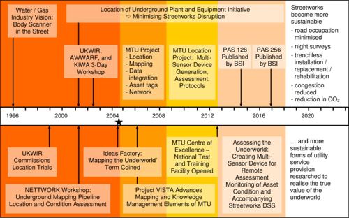
MTU and ATU Timeline
Outputs
Download the end of project brochure: Assessing the underworld - An integrated model of City Infrastructures
Visit the publications page for a full list of Academic and professional journals, conference papers, articles, reports, presentations and books.
Mapping Britain’s Underworld on Radio 4
Mapping Britain’s Underworld’ was presented by Adam Hart-Davies and produced by Sara Parker. It was a Unique production for BBC Radio 4 originally broadcast in May 2012
Audio Player